Vineyard Canopy Segmentation
Multi-scale grapevine canopy segmentation from UAV RGB imagery
Introduction
The usage of Unmanned Aerial Vehicles (UAVs) in precision agriculture has been rapidly shaping modern agricultural practices, enabling farmers to monitor crop health, optimize resource usage, and improve yields. In viticulture, the segmentation of vineyard canopy from aerial imagery is a critical task for assessing vine vigor, detecting diseases, and guiding management decisions.
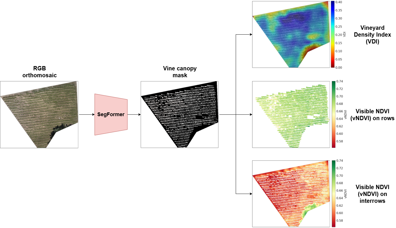
This solution provides automatic grapevine canopy segmentation from UAV imagery using deep learning. The method is designed for RGB orthomosaics acquired with low-budget drones and addresses two key practical challenges in computer vision-based vineyard monitoring: strong visual heterogeneity (lighting changes, shadows, spontaneous vegetation, soil variability) and different image scales (ground sample distance, GSD). The output is a binary segmentation mask that separates vineyard canopy from background and can be used for downstream vegetation analysis. Ultimately, the mask can be used to compute canopy-centric indicators such as the Vineyard Density Index (VDI) and the Visible NDVI (vNDVI) on canopy and non-canopy pixels, supporting agronomic interpretation of canopy vigor and inter-row vegetation conditions.
Key Features
- Multi-Scale Training Strategy: the model has been trained on multiple resized versions of the same orthoimages so the model remains effective across a wide GSD range, including lower-resolution surveys.
- Strong Augmentation Pipeline: strong geometric and radiometric augmentations have been applied during training to improve robustness to heterogeneous visual conditions typical in vineyard environments.
- Transformer-Based Segmentation: the backbone is a SegFormer MiT-B5 achieving competitive and consistent performance.
- Cross-Domain Generalization: the model has been trained on an open-access dataset of vineyard images and tested successfully on unseen images of vineyards in other regions of Europe (collected during the VITIGEOSS project).
- Operational Monitoring Output: supports vineyard analysis through canopy masks and density/greenness indicators for agronomic decision support.
Technologies Used
- UAV RGB Orthomosaics: high-resolution aerial RGB imagery for vineyard canopy delineation.
- Computer Vision: our model is a finetuned SegFormer MiT-B5 , which beats the performance of the UNet ResNet-34 baseline presented in Barros et al. (2022).
- Python Libraries: pandas for data handling, albumentations for data augmentation, PyTorch for model training, matplotlib for data visualization.
Use Cases
- Canopy Mapping at Parcel Scale: Produce accurate canopy masks from routine UAV surveys, robust to lighting changes, shadows2, inter-row vegetation, shape of the canopy.
- Vegetation Status Monitoring: Derive canopy-centric indicators to track vigor, anomalies, and potential stress, ultimately supporting irrigation, fertilization, and disease monitoring workflows.
Benefits
- Works with RGB-only data from low-cost drone setups
- Handles heterogeneous vineyard conditions and shadows robustly
- Maintains strong performance across different image scales
- Enables downstream, map-based monitoring analytics
Demo
Integration
The solution can be integrated into UAV monitoring pipelines where orthomosaics are periodically generated for vineyard parcels. After segmentation, canopy masks can be ingested into GIS dashboards or analytics tools to compute vegetation indices.
We provide:
- Test dataset: links-ads/gaia-vineyard-uav-dataset
- Trained segmentation model: links-ads/gaia-growseg
Publications
This solution is based on the paper A multi-scale vineyard canopy segmentation method for aerial RGB images which is soon to be published.
Aknowledgements
According to the paper, this work was financially supported by:
- VITIGEOSS - European Commission (Grant Agreement No. 869565)
- GUARDIANS - European Commission (Grant Agreement No. 101084468)