Urban Air Quality Forecasting
Produce Urban Air Quality high-resolution forecast map using satellite, meteorological and geospatial data.
Introduction
Air pollution is a major environmental and public health challenge in urban areas. Pollutants such as PM2.5, PM10, NO2, and O3 require accurate spatial monitoring to support environmental management and policy making. However, urban air quality monitoring typically relies on sparse ground-based stations, which provide accurate measurements but cannot capture the strong spatial variability of pollutant concentrations across cities.
Satellite observations offer complementary large-scale atmospheric information, but their spatial resolution is generally insufficient to represent urban-scale pollution dynamics.
Urban Air Quality Forecasting tackles this problem by formulating pollutant estimation as a supervised regression task that combines satellite observations (Sentinel-5P), meteorological variables, and geospatial features such as land cover and digital elevation models. Machine learning models, including Random Forest and XGBoost, are trained to reproduce measurements from urban monitoring stations and generalize these relationships across the city.
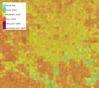
The resulting system produces 500 m resolution maps of major urban pollutants, enabling detailed air quality assessment even in areas without monitoring stations and supporting early warning and urban planning applications.
Key Features
- High-resolution pollution mapping: Generates urban air quality maps with a spatial resolution of approximately 500 meters.
- Multi-source data fusion: Integrates satellite observations, meteorological variables, and geographic features to estimate pollutant concentrations.
- City-wide coverage: Produces pollution estimates even in areas where ground monitoring stations are not present.
Technologies Used
- Machine Learning: Supervised learning models trained to reproduce ground station measurements of pollutant concentrations.
- Computer Vision: Satellite-derived atmospheric information is used as input features.
- Other: Geospatial data processing and environmental data fusion including satellite products, land cover information, and meteorological datasets.
Use Cases
One of the main applications of the solution is early warning for air pollution events. By forecasting pollutant concentrations across the urban area, the system can help authorities inform citizens about potential health risks during severe atmospheric conditions.
Another key use case is urban pollution hotspot detection. High-resolution pollution maps allow decision makers to identify areas where pollutant concentrations are consistently higher, supporting urban planning strategies, mobility policies, and environmental interventions aimed at improving air quality.
Live Demo
Input
The model takes as input multiple environmental datasets, including:
- Satellite observations from Sentinel-5
- Digital Elevation Model (DEM)
- Land cover information
- Meteorological variables
How it works
Machine learning models are trained using historical pollutant measurements collected from urban monitoring stations. Environmental and geospatial variables are used as predictors, allowing the model to learn the relationship between atmospheric conditions, geographic characteristics, and pollutant concentrations.
Two machine learning approaches have been explored:
- Random Forest
- XGBoost
Once trained, the model can estimate pollutant concentrations for every grid cell of the target city at 500 m resolution.
Output
The system generates spatial maps of the five major air pollutants:
- PM2.5
- PM10
- NO2
- O3
- Air Quality Index (AQI)
Try it out
Try out the solution in real time on Hugging Face Spaces:
Benefits
- Increased environmental monitoring coverage
- Early detection of air pollution events
- Support for data-driven urban planning
- Improved spatial understanding of pollution dynamics
Integration
The solution can be integrated into environmental monitoring platforms, smart city dashboards, or public information systems. The generated pollution maps can support municipal authorities, environmental agencies, and researchers in monitoring urban air quality and developing mitigation strategies.
Publications
The developed model is described in the article Urban air pollution forecasting: a machine learning approach leveraging satellite observations and meteorological forecasts accepted and presented at the 2024 IEEE International Workshop on Metrology for Living Environment (MetroLivEnv)
Acknowledgements
This work was partially funded by:
- UP2030 - Horizon Europe Programme under Grant Agreement No. 101096405
References
2024
- Urban Air Pollution Forecasting: a Machine Learning Approach leveraging Satellite Observations and Meteorological Forecasts2024