Rooftop Solar Potential Estimation
Estimate rooftop photovoltaic potential from aerial images using deep learning segmentation and geospatial analysis.
Introduction
The rapid expansion of distributed solar energy requires scalable tools to assess where rooftop photovoltaic (PV) installations are viable. Traditional survey-based approaches are slow, costly, and impractical at city or regional scale. At the same time, urban areas present complex roofscapes — varying roof orientations, slopes, materials, and obstructions — that require fine-grained spatial analysis to evaluate solar suitability accurately.
Rooftop Solar Potential Estimation addresses this challenge by formulating the problem as a semantic segmentation task on high-resolution aerial imagery. Deep learning models are trained to detect and delineate individual rooftop surfaces, classify their geometry (flat vs. pitched), and estimate their orientation. These attributes are then fed into an established photovoltaic simulation tool to produce per-rooftop energy yield estimates.
The resulting system enables automated, city-scale mapping of rooftop solar potential, supporting energy planners, municipal authorities, and building owners in identifying the most promising locations for PV deployment.
Key Features
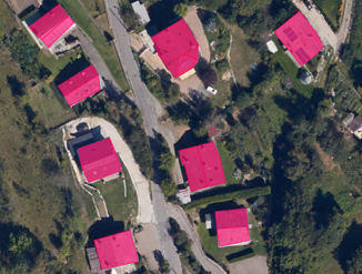
- Rooftop detection and segmentation: Identifies rooftop surfaces at pixel level from aerial imagery, producing accurate building footprint masks.
- Geometry classification: Distinguishes between flat and pitched roofs and estimates orientation with respect to north — key inputs for solar yield calculation.
- Solar yield estimation: Integrates with PVGIS, the EU photovoltaic geographical information system, to convert rooftop geometry into annual and monthly energy production forecasts.
Technologies Used
- Machine Learning: Supervised semantic segmentation models (UNet with ResNet50 encoder) trained to delineate rooftop surfaces and classify geometric attributes.
- Computer Vision: High-resolution aerial imagery (≈15 cm/pixel) used as primary input, with deep learning architectures including ResNet50, Vision Transformer (ViT), and Hiera evaluated as encoders.
- Other: Post-processing algorithms for rooftop polygon regularisation and geometric attribute extraction; integration with PVGIS for photovoltaic simulation; transfer learning across multiple international datasets.
Use Cases
A primary application is urban solar resource mapping. By processing aerial imagery of an entire municipality, the system can generate a ranked inventory of rooftops ordered by estimated annual energy yield, enabling planners to prioritise areas for incentive programmes or grid reinforcement.
Live Demo
Input
The model takes as input:
- High-resolution aerial RGB imagery (≈15 cm/pixel)
- Geographic coordinates of the target area
How it works
A UNet architecture with a ResNet50 encoder is trained on multiple datasets — AIRS, RID, and DeepRoof — using a two-stage transfer learning strategy. In the first stage, the model learns to separate roof pixels from background. In the second stage, fine-tuning on labelled datasets adds the ability to classify roof type (flat vs. pitched) and estimate orientation.
A dedicated auxiliary decoder output predicts rooftop perimeter edges alongside the main segmentation mask, improving boundary delineation. A post-processing algorithm then converts the raw pixel-level predictions into regularised rooftop polygons from which geometric attributes are extracted:
- Rooftop surface area
- Orientation with respect to north
- Roof type (flat or pitched)
These attributes are submitted to PVGIS — the EU photovoltaic geographical information system — which returns estimated annual, monthly, and daily energy production figures based on historical solar radiation data.
Three encoder architectures have been compared:
| Encoder | F1 Test | IoU Test |
|---|---|---|
| ResNet50 | 85.99% | 75.92% |
| Hiera | 82.42% | 70.84% |
| ViT | 62.80% | 47.95% |
ResNet50 achieves the best balance of accuracy and training efficiency on the available data.
Output
The system generates:
- Rooftop segmentation masks with per-polygon geometry attributes
- Estimated annual PV energy yield (kWh/year) per rooftop
- Monthly and daily production profiles from PVGIS
- Existing PV panel delineation with regularised polygon boundaries
Try it out
Try out the solution in real time on Hugging Face Spaces:
Benefits
- Scalable assessment of solar energy potential without field surveys
- Fine-grained rooftop-level yield estimates based on actual geometry and orientation
- Combined view of existing installations and remaining untapped potential
- Support for evidence-based solar energy policy and urban planning
Integration
The solution can be integrated into smart city platforms, energy management dashboards, or GIS environments. Output data — rooftop polygons enriched with solar potential attributes — can be exported in standard geospatial formats (GeoJSON, Shapefile) for use by municipal authorities, energy agencies, and building managers. The modular pipeline allows individual components (segmentation, panel detection, PVGIS query) to be deployed independently or as a complete end-to-end service.
Acknowledgements
This work was partially funded by:
- NODES – Nord Ovest Digitale e Sostenibile – MUR Missione 4, Componente 2, Investimento 1.5 – Creazione e rafforzamento di “Ecosistemi dell’innovazione”, funded by the European Union – NextGenerationEU, Grant Agreement No. ECS00000036
- PERFORM project – NODES Spoke N4