Landslide Segmentation from S2
Landslide mapping from Sentinel-2 imagery through change detection
Introduction
Landslides are one of the most critical and destructive geohazards. Widespread development of human activities and settlements combined with the effects of climate change on weather are resulting in a high increase in the frequency and destructive power of landslides, making them a major threat to human life and the economy.
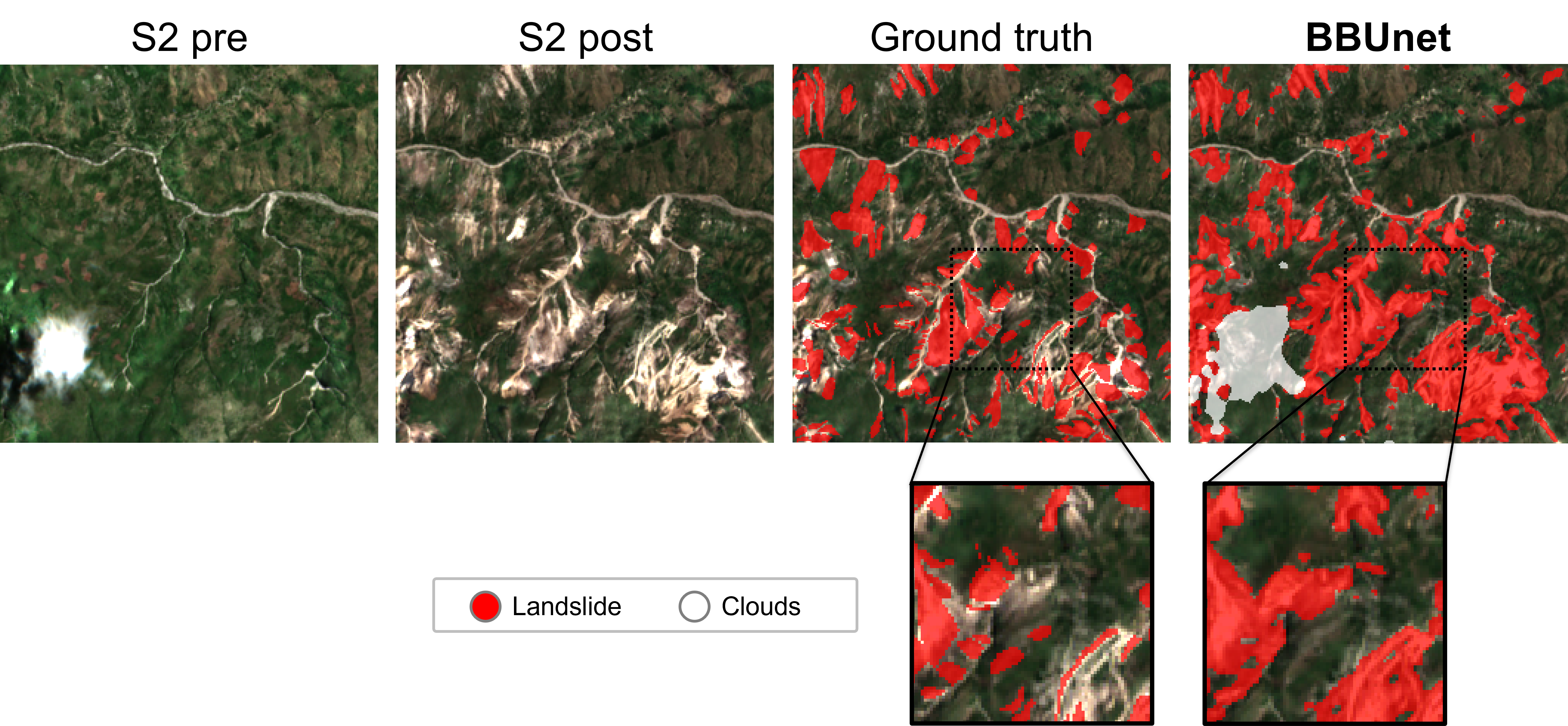
This solution uses a newly developed AI model called BBUnet (Bitemporal Bimodal Unet) to automatically map co-hazard landslides from satellite imagery. The approach frames landslide delineation as a bi-temporal change detection task, using a pair of Sentinel-2 images acquired before and after a landslide-triggering event. To improve detection quality, the system is also bi-modal, as it incorporates Digital Elevation Model (DEM) data and derived data (slope and aspect). The result is a binary segmentation map highlighting areas impacted by newly activated landslides, supporting rapid post-event analysis over large regions.
To train the model, the authors built a large and diverse geodatabase of 34,920 manually validated landslide polygons from five different open-access inventories across Haiti, Indonesia, China, Colombia, and Japan. To further improve robustness, our training pipeline also includes a cloud masking model to filter out cloud pixels and a strong image augmentation strategy employing both geometric and color transformation.
Key Features
- Bitemporal landslide detection: Uses pre-event and post-event Sentinel-2 acquisitions to focus only on co-hazard landslides instead of older pre-existing scars.
- Bitemporal-bimodal fusion: Introduces BBUnet, a dedicated architecture that combines Sentinel-2 pre-post image pairs with DEM-derived data to improve landslide delineation.
- Harmonized landslide geodatabase: Built from five manually validated open-access inventories across Haiti, Indonesia, China, Colombia, and Japan, spanning heterogeneous ecoregions and triggering events.
- Competitive performance on open data: In the reported experiments, BBUnet achieved the best overall F1 score among the tested change detection models.
Technologies Used
- Satellite data: Pre-event and post-event Sentinel-2 images and ALOS PALSAR DEM data.
- Computer Vision: Change detection models including UNet-Siam-Diff, BIT, SEIFNet, TinyCD, and the proposed BBUnet.
- Cloud Masking: Automatic cloud filtering based on OmniCloudMask.
- Training frameworks: All experiments were implemented in PyTorch; training was performed on a NVIDIA A100 GPU.
Use Cases
- Rapid Post-Event Mapping: Delineate landslides as soon as Sentinel-2 imagery becomes available after earthquakes or heavy rainfall events to support emergency response.
- Disaster Impact Assessment: Estimate the spatial extent of slope failures affecting settlements, roads, and exposed infrastructure.
- Hazard Monitoring: Update landslide inventories over large and visually diverse regions using medium-resolution open satellite data.
- GIS and Civil Protection Workflows: Provide landslide masks that can be integrated into operational mapping platforms for situational awareness and planning.
Benefits
- Focuses on newly triggered landslides through change detection
- Leverages open-access satellite and terrain data
- Trained on a geographically diverse multi-event database
Live Demo
Integration
This solution can be integrated into disaster management and geospatial analysis workflows that already use Sentinel-2 imagery. Given a pre-event and post-event image pair for the same area, the model generates a binary landslide segmentation mask that can be ingested into GIS platforms, rapid mapping pipelines, or damage assessment dashboards.
The accompanying open-source repository provides access to the methodology and dataset used in the paper, enabling organizations and researchers to reproduce the pipeline or adapt it to their own regions of interest: links-ads/igarss-landslide-delineation.
Publications
The methodology and dataset were presented in the paper “Landslide Mapping from Sentinel-2 Imagery through Change Detection” (published at IGARSS 2024)
Acknowledgements
This work was partially funded by:
- ATLANTIS - Horizon Europe Programme under Grant Agreement No. 101073909
- RescueME - Horizon Europe Programme under Grant Agreement No. 101094978
- NODES - MUR-M4C2 1.5 of PNRR under Grant ECS00000036