Land Cover Segmentation
Pan-European Multi-Seasonal Land Cover Mapping
Introduction
Accurate land cover mapping is essential for a wide range of applications, including environmental monitoring, wildfire risk assessment and urban planning. Manual annotation, however, is time-consuming, expensive, and difficult to scale, creating a strong need for automated, large-scale solutions. Effective models must also handle variations across locations and seasons. To address these challenges, we developed a robust pan-European land cover mapping deep learning model using multi-seasonal Sentinel-2 imagery, designed for reliable, continent-wide performance.
Key Features
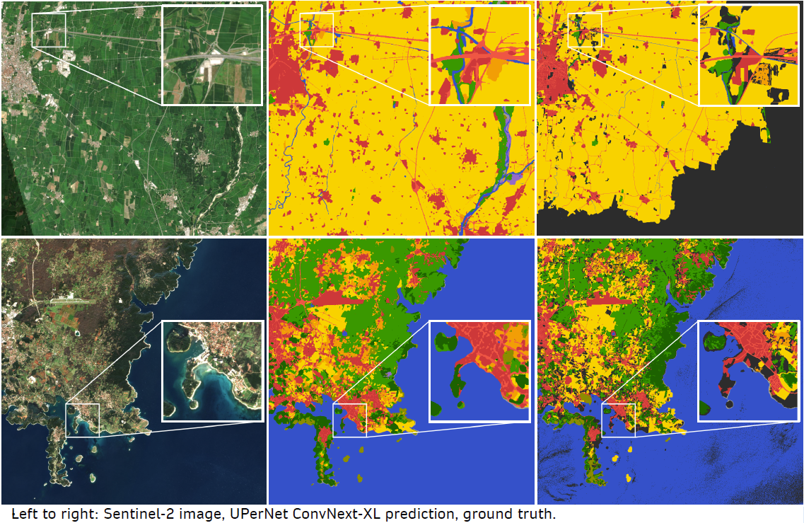
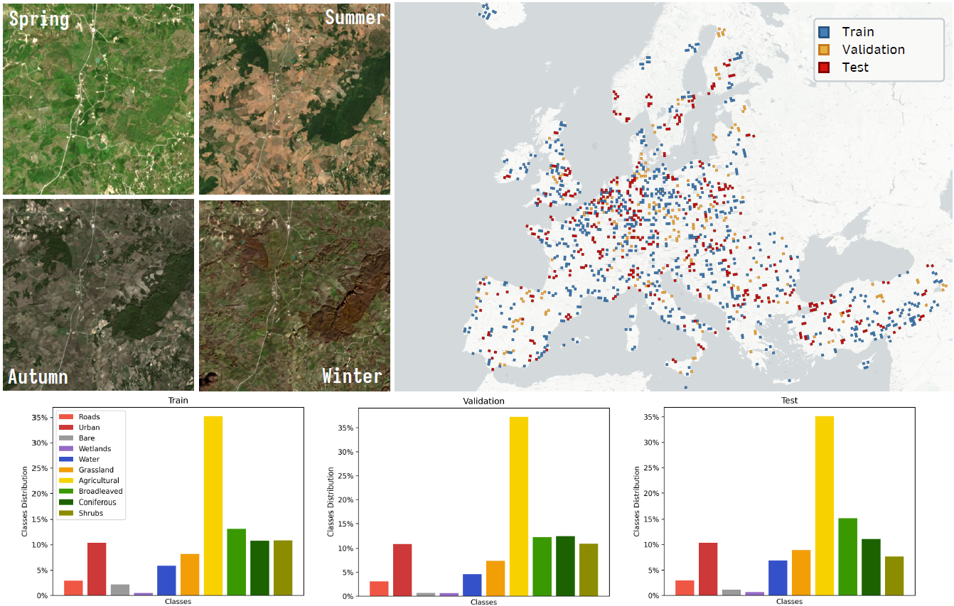
- Dataset: The dataset consists of Sentinel-2 imagery at 10m pixel resolution, including 10 spectral bands, with tiles of 2048x2048 pixels. It is split into 56% for training (425 cities, 3,025 tiles), 14% for validation (123 cities, 756 tiles), and 30% for testing (201 cities, 1,620 tiles).
- Land Cover Classes: The model supports 10 land cover classes, with focus on fuel maps for wildfires: Roads, Urban, Bare Surfaces, Wetlands, Water, Grassland, Agricultural, Broadleaved Forest, Coniferous Forest and Shrubs.
- Spatial Coverage: 749 European cities across diverse climatic zones
- Temporal Coverage: Multi-seasonal acquisitions (Spring, Summer, Autumn, Winter), created as cloud-free mosaics aggregated over several months.
Technologies Used
- Python: Primary programming language, leveraging libraries such as NumPy and PyTorch for numerical computing and deep learning.
- PyTorch Lightning: Framework simplifying and structuring deep learning training and testing loops.
- MMSegmentation: Library providing state-of-the-art semantic segmentation models and tools.
- Segmentation Models Pytorch: Collection of pre-implemented semantic segmentation architectures for PyTorch.
- Rasterio: Library for reading, writing, and processing georeferenced raster data.
- CUDA: GPU acceleration platform enabling faster model training and inference.
Use Cases
- Wildfire Risk Assessment: Identify vegetation types and fuel loads to support fire prevention and management.
- Urban Planning: Map built-up areas and land-use changes to guide sustainable city development.
- Biodiversity and Conservation: Monitor habitats and natural areas to support conservation efforts.
- Flood and Water Management: Map water bodies and land cover changes to improve flood prediction and resource planning.
- Deforestation and Land Degradation Monitoring: Detect changes in forest cover and land degradation over time.
- Climate and Environmental Studies: Provide high-resolution land cover data for climate modeling and environmental research.
Benefits
- Reliable and accurate predictions
- High resolution mapping
- Pan-European coverage
- Robust to seasonal variations
Integration
The land cover model can be seamlessly integrated into existing business processes and systems by providing automated, high-resolution maps for decision-making. It can feed directly into GIS platforms, environmental monitoring dashboards, or agricultural management tools, enabling real-time analysis of land-use changes, vegetation health, and urban expansion. By incorporating model outputs into operational workflows, organizations can improve planning, optimize resource allocation, and enhance risk management with minimal manual effort.
Publications
The dataset and the model were showcased in a poster presentation at the ESA Living Planet Symposium 2025 in Vienna.
Aknowledgements
The development of the model was funded by:
- RescueME - Horizon Europe Programme (HORIZON-CL2-2022-HERITAGE-01-08) under Grant Agreement No. 101094978
- FUTUREFOR - Horizon Europe Research and Innovation Programme (HORIZON-EUSPA-2023-SPACE) under Grant Agreement No. 101180278
- Space It Up - Italian Space Agency and the Ministry of University and Research - Contract No. 2024-5-E.0 - CUP No. I53D24000060005